 03-03-2015, 01:23 AM
|
#2342 |

Join Date: Jul 2008
Location: Idaho
Posts: 25,054
|
Thank you for your kind words.
 I really enjoyed following the Minben sail down the Yangtze River to Shanghai. However, I didn't think I would enjoy watching the Hanjin Germany sail across the ocean to Long Beach; I was mistaken. I didn't anticipate the vessel would follow these interesting chains of islands which possess such beautiful landscapes and wildlife. 
__________________
Spud "Never argue with an idiot. He will drag you down to his level, and beat you with experience."  Mark Twain Mark Twain2015 Zongshen ZS250GY-3 (RX3) 2006 Zongshen ZS200GY-2 (Sierra 200) 2005 Honda XR650L 2004 Honda CRF250X 1998 Kawasaki KDX220 Mods made to my Zongshen ZS200GY-2: http://www.chinariders.net/showthread.php?t=6894 |

|
|
03-03-2015, 02:01 AM
|
#2343 | |

Join Date: Sep 2014
Posts: 175
|
Quote:
 Depending on when the bikes actually show up at your shop, I'd like to try to pick mine up in April. Depending on when the bikes actually show up at your shop, I'd like to try to pick mine up in April.
__________________
Honda CB300R ABS |
|
|
|
|
03-03-2015, 02:43 AM
|
#2344 |
|
Join Date: Jul 2008
Location: Idaho
Posts: 25,054
|
Louis is a native Aleut who was born and raised on Atka Island. He makes a strong case for eating a natural diet.
__________________
Spud "Never argue with an idiot. He will drag you down to his level, and beat you with experience." Mark Twain2015 Zongshen ZS250GY-3 (RX3) 2006 Zongshen ZS200GY-2 (Sierra 200) 2005 Honda XR650L 2004 Honda CRF250X 1998 Kawasaki KDX220 Mods made to my Zongshen ZS200GY-2: http://www.chinariders.net/showthread.php?t=6894 |
|
|
|
03-03-2015, 03:01 AM
|
#2345 |
|
Join Date: Jul 2008
Location: Idaho
Posts: 25,054
|
Fifteen minutes ago the Hanjin Germany surprised me. The vessel is now sailing southeast at 13.6 knots, and appears to be heading for Amukta Pass between the islands of Seguam and Amukta. The vessel was last located at the position shown below, which is farther south than Prince Rupert, British Columbia.
LAT: 53° 14' N LONG: 173° 40' W If the Germany continues on this heading, it will enter the North Pacific Ocean, cross the Aleutian Trench, and leave the Aleutian Islands behind as it sails across the open sea to Long Beach.
__________________
Spud "Never argue with an idiot. He will drag you down to his level, and beat you with experience." Mark Twain2015 Zongshen ZS250GY-3 (RX3) 2006 Zongshen ZS200GY-2 (Sierra 200) 2005 Honda XR650L 2004 Honda CRF250X 1998 Kawasaki KDX220 Mods made to my Zongshen ZS200GY-2: http://www.chinariders.net/showthread.php?t=6894 |
|
|
|
03-03-2015, 08:20 AM
|
#2346 |
|
Banned
Join Date: Oct 2014
Posts: 223
|
Odd
I agree Spud, It seems kinda odd the ship is taking that route. I'd think they would preferr the open ocean so as to not be "dodging" the obstacles (islands
.. Those latitudes I think I read in a cruising magazine or forum, cause you to appear to be on a curving route, but actually to go shortest distance, it LOOKS loke a curve due to earth shape being round.Also something to the effect that further North the line/path, the more it appears to curve, I believe. Maybe the routes are planned to avoid weather exposure on the open ocean, not encountering any large seas/Rogue Wave chances reduced, as they can duck behind an island for a while if need be? I have read that containers, somewhat more than you'd expect, do get swept off container ships at times. Cruisers are in dread of hitting them in the open ocean, and there are quite a few documented cruisers sinkings, and extensive boat damage from hitting then as they are 99% invisible under water, especially in waves or at night. ANyway, seems they are making sure the bikes ae transported safe and sound, steady progress is being made, and It seems all will be undamaged and delivered to Long Beach as scheduled, and thats a very good thing, for everyone involved, IMHO !
|
|
|
|
03-03-2015, 08:52 AM
|
#2347 |

Join Date: Feb 2015
Posts: 43
|
Ships route
For 35 years I was a helicopter pilot for the USCG and was stationed in Kodiak for 2 of those years. Our job was to fly off the back of 365 foot USCG Cutters, (ships), in the Bering and around the islands. Now I wasn't the guy driving the ship but I can tell you that there are very heavy seas in that area. Often times we'd have to tuck into the lee of land just to keep the ship from being damaged. We were in a storm once in that area approaching Unimak where we had 65ft seas and 90+ knot winds. You have to sail with caution in that area of the world. This may explain the route the ship takes. And yes container do get washed overboard all over the world. Many times they just sink, but not always. A floating container is a hazaed to navigation. I deployed 32 times in my career and spent more time at sea, (with a helicopter), than most guys who chose ship driving as their primary duty. I had over 1100 days of underway time. That's more than 3 years of actual underway time. Most boat drivers don't see that kind of sea time in a career, they might be stationed on a ship, but a large part of that time is tied to the pier. Anyway, this might help explain the route the ship is taking, plus remember that the insurance companies expect ships to stay in the established shipping lanes for the most part for liability reasons.

|
|
|
|
03-03-2015, 09:35 AM
|
#2348 |
|
Banned
Join Date: Oct 2014
Posts: 223
|
Aha!
Thanks for clarifying that, veteran. Wow, I can't IMAGING 50' much less 65' seas. I was in some 14-16 foot seas coming back from St Thomas USVI to ST Croix (hurricane work after Hugo, 1990-1992), and was ferrying some badhung over guys in my 22 cuddy STamas outboard fishing boat. We were getting swept, almost every wave
! They were wide eyed and puking! hehe. SHouldn't have made me wait 1.5 hrs w/o a call then wanted to go back anyway...OK I says, and we did. Was barely on plane to keep the bow up as far as possible above the water. Its a self bailing design, but I hap pumps on and plug removed for water to get out ASAP. Interesting 4 hour (46 miles or so), trip.That was somewhat scary, but anything more, and WOW! Those container ships decks are waaay above water normally, correct? So it would take some wave just to reach the deck, I'd think. Probably some containers slide off when its rolling the ship badly, right? The currents make waves "stack up" in that area also, correct? |
|
|
|
03-03-2015, 10:27 AM
|
#2349 | |

Join Date: Mar 2009
Location: Sardis, BC, Canada
Posts: 25,977
|
Quote:
__________________
Weldangrind "I figure I'm well-prepared for coping with a bike that comes from the factory with unresolved issues and that rewards the self-reliant owner." - Buccaneer |
|
|
|
|
03-03-2015, 10:40 AM
|
#2350 | |
|
Join Date: Mar 2009
Location: Sardis, BC, Canada
Posts: 25,977
|
Quote:
__________________
Weldangrind "I figure I'm well-prepared for coping with a bike that comes from the factory with unresolved issues and that rewards the self-reliant owner." - Buccaneer |
|
|
|
|
03-03-2015, 10:41 AM
|
#2351 | |
|
Join Date: Mar 2009
Location: Sardis, BC, Canada
Posts: 25,977
|
Quote:
__________________
Weldangrind "I figure I'm well-prepared for coping with a bike that comes from the factory with unresolved issues and that rewards the self-reliant owner." - Buccaneer |
|
|
|
|
03-03-2015, 12:47 PM
|
#2352 | ||
|
Join Date: Jul 2008
Location: Idaho
Posts: 25,054
|
Quote:
This path does appear as an arc when represented on a two-dimensional map.Most vessels sailing from Japan to Long Beach follow the path through Unimak Pass, as shown on the drawing below. Therefore, I was surprised when the Hanjin Germany started turning for a pass in the middle of the Aleutians. Quote:
I'm sure you are correct. About 4 hours ago, the Hanjin Germany was entering Amukta Pass, and preparing to leave the Bering Sea. The last recorded location of the vessel is shown as point #3 in the drawing below. Amukta island is the top of a volcano, and is shown in the photograph below.  Seguam Island is slightly larger, and contains two volcanic calderas. Here is a photograph of Pyre Peak from the western part of the island. 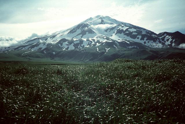 Here is an aerial photograph showing lava erupting from the same peak.  The vessel was last recorded at the following position, sailing southeast at 11.8 knots. LAT: 52° 33' N LONG: 172° 02' W The ETA in Long Beach has been pushed back to March 11, at 11:30 AM, PDT.
__________________
Spud "Never argue with an idiot. He will drag you down to his level, and beat you with experience." Mark Twain2015 Zongshen ZS250GY-3 (RX3) 2006 Zongshen ZS200GY-2 (Sierra 200) 2005 Honda XR650L 2004 Honda CRF250X 1998 Kawasaki KDX220 Mods made to my Zongshen ZS200GY-2: http://www.chinariders.net/showthread.php?t=6894 Last edited by SpudRider; 03-03-2015 at 03:16 PM. |
||
|
|
|
03-03-2015, 12:51 PM
|
#2353 | |
|
Join Date: Jul 2008
Location: Idaho
Posts: 25,054
|
Quote:
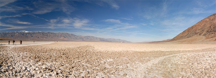
 In contrast, the Bonneville Salt Flats have an elevation of 4,219 feet above sea level. In contrast, the Bonneville Salt Flats have an elevation of 4,219 feet above sea level.
__________________
Spud "Never argue with an idiot. He will drag you down to his level, and beat you with experience." Mark Twain2015 Zongshen ZS250GY-3 (RX3) 2006 Zongshen ZS200GY-2 (Sierra 200) 2005 Honda XR650L 2004 Honda CRF250X 1998 Kawasaki KDX220 Mods made to my Zongshen ZS200GY-2: http://www.chinariders.net/showthread.php?t=6894 |
|
|
|
|
03-03-2015, 01:05 PM
|
#2354 |
|
Join Date: Sep 2014
Posts: 1,870
|
Death Valley NP ranges in elevation from below sea level to over 11,000' so it can be quite cold at higher elevations. I was there a couple weeks ago. Anyone interested in camping and riding at Grand Canyon north rim in July let me know. We'll have a group of small cc bike riders down there for 9 days.
|
|
|
|
03-03-2015, 01:14 PM
|
#2355 |
|
Join Date: Jul 2008
Location: Idaho
Posts: 25,054
|
Here is a short video showing a container vessel encountering rough seas between San Francisco and Long Beach.
 The Hanjin Germany will be sailing the high seas for the rest of its journey to Long Beach. The Hanjin Germany will be sailing the high seas for the rest of its journey to Long Beach.
__________________
Spud "Never argue with an idiot. He will drag you down to his level, and beat you with experience." Mark Twain2015 Zongshen ZS250GY-3 (RX3) 2006 Zongshen ZS200GY-2 (Sierra 200) 2005 Honda XR650L 2004 Honda CRF250X 1998 Kawasaki KDX220 Mods made to my Zongshen ZS200GY-2: http://www.chinariders.net/showthread.php?t=6894 |
|
|
|
|

|
 |
|
|


 Linear Mode

